


This component enables you to display real-time status indicators on a geographical map, with the view's CIs at the geographical locations they are related to. The status indicator shows the worst status of the CIs at the geographical location. You can also access detailed information about the CI's KPIs.
-
If you have an Internet connection, Geographical Maps are displayed using Virtual Earth.
-
If you do not have an Internet connection, Geographical Maps are displayed using an Offline Map.
-
You can also view the Geographical Map information in a three-dimensional map, using the Google Earth application.
You can create your own pages and include this component. For details, see Set up My Workspace.
Learn More
The map displays color-coded status indicators that represent the worst KPI status for all CIs attached to the location at each geographical location. The color coding is the same as for other icons in Service Health.
To specify a location, create CIs of the type location and then create relationships between the location CIs and the CIs for which you want to display status indicators in the Geographical Map. For details, see "Working with Relationships" in the
Each status indicator in the map can represent one or more CIs from the view with the same location. If you select a CI in View Explorer, the Geographical Map is redisplayed automatically and shows only the selected CI and the CI's children status indicators if a location is specified for them. If you select another view, the Geographical Map reloads automatically to show the view's CI status indicators in the appropriate locations.
Note The Offline Geographical Map does not respond to changes in the CI selection because the Offline Map and View Explorer are not wired.
If you search for a specific CI in View Explorer and you click the result of the search, the Geographical Map is not automatically redisplayed. The map is redisplayed only when you go back to browser mode. It shows only the selected CI and the CI's children status indicators if they are related to a location CI.
If you have an Internet connection, the Geographical Map is displayed by default using Microsoft MSN Virtual Earth. Virtual Earth presents a flat geopolitical view of the planet where you can display country borders, geographical features, or both. If the view's CIs are assigned geographical locations, real-time status indicators are displayed on the map at those geographical locations.
Note The Virtual Earth map is only available in English and cannot be translated.
Example of Virtual Earth:
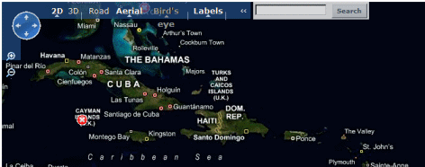
The Virtual Earth Geographical Map presents a flat geopolitical view of the planet where you can display the country borders, the geographic features, or both.
When you magnify the view, the main cities appear for the part of the map that is displayed on the screen.
If you do not have an internet connection, the Geographical Map page displays as offline map if the Use Virtual Earth infrastructure setting is set to False. The map displays the worst status at each geographical location and detailed information about the CI's KPIs.
Example of the offline map:
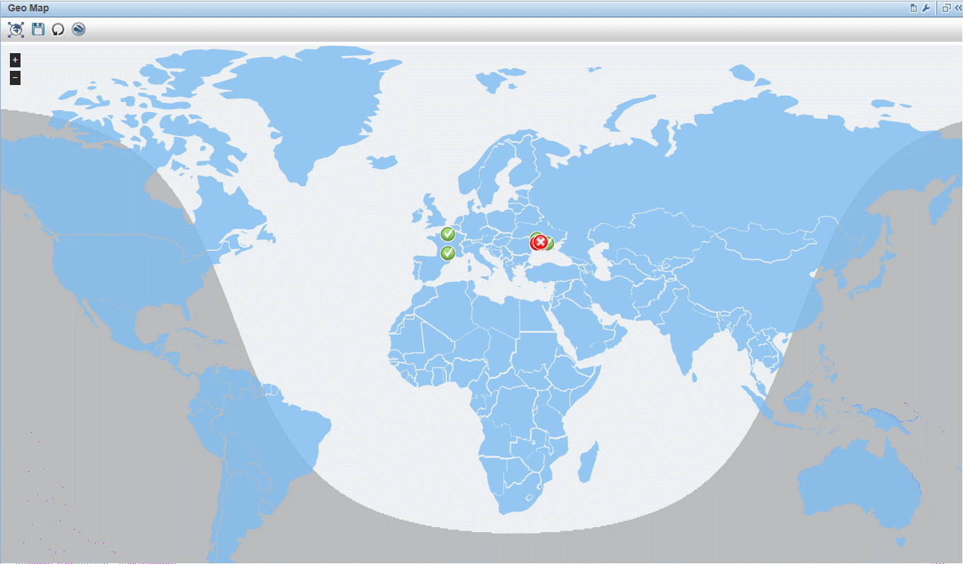
The default color for the offline map is blue.
The map provides a day-night overlay option, which shows an approximation of the day/night line.
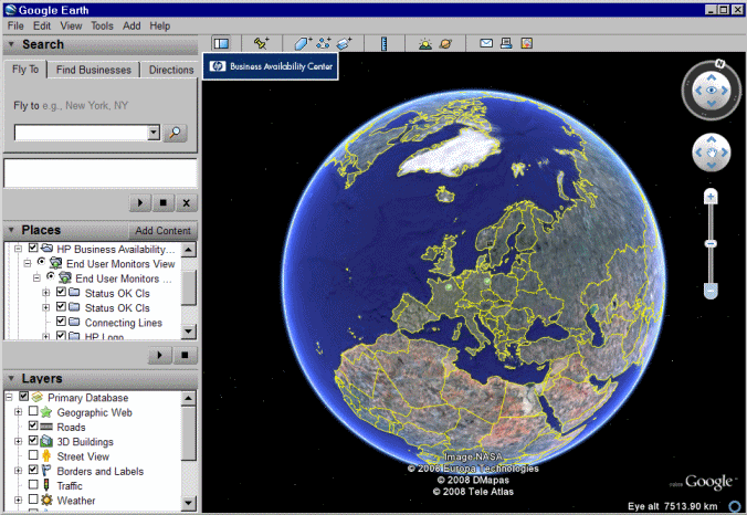
You can view the Geographical Map information in a three-dimensional map, using the Google Earth application.
Example of Google Earth:
Tasks
You work with Geographical Map in a few stages:
-
Within RTSM Administration, you create CIs of the type location and then create relationships between the location CIs and the CIs for which you want to display status indicators.
-
In Service Health Administration, you then optionally specify the type of map you will use and configure the map. For details, see
-
Within Workspaces, you then add the Geographical Map and View Explorer components to a page. When you access the page you see the CI statuses in the view, based on their geographic locations.
Note You can modify refresh rates using the
 Component Menu button on the component toolbar. Select Preferences, and change the refresh rate as needed.
UI Descriptions
User interface elements are described below (unlabeled elements are shown in angle brackets):
|
UI Element (A-Z) |
Description |
|---|---|
|
|
Click to zoom out completely. |
|
|
Click to save changes to the Geographical Map display. |
|
|
If you made changes to your map which you do not want to save, click to revert to the last saved version of the map. |
|
|
Click to open the Geographical Map for the view using Google Earth. |
|
|
Enable you to zoom in and out to enlarge or shrink the map. |
|
|
Click to shift the center of the map to the nearest CI. |
|
|
Click to zoom out completely. |
| <Adjustments> |
Click the map and drag to move the map in the window. Double-click the map to zoom in. |
| <Status of a location>
|
The Geographical Map of the view displays the worst status at each geographical location. The color coding is the same as for other icons in Service Health. |
| <Tooltip> |
Move the cursor above a status icon to display the location tooltip that provides the worst status for all KPIs associated with the location. A KPI is associated with a location if that KPI is assigned to at least one of the CIs related to the corresponding location CI. The tooltip includes the following information:
|
| Last Update |
Displays when the information in the component was last updated. To manually update the information in the component, click the Refresh icon. |
| Road/Aerial/Bird's Eye/Hybrid/Labels |
Click:
|
| Search |
Use this feature to perform a search in Microsoft MSN Virtual Earth (outside of OMi). |


User interface elements are described below (unlabeled elements are shown in angle brackets):
|
UI Element (A-Z) |
Description |
|---|---|
|
|
Click to zoom out completely. |
|
|
Click to save changes to the Geographical Map display. |
|
|
If you made changes to your map which you do not want to save, click to revert to the last saved version of the map. |
|
|
Click to open the Geographical Map for the view using Google Earth. |
|
|
Enable you to zoom in and out to enlarge or shrink the map. |
| <Status of a location>
|
The Geographical Map of the view displays the worst status at each geographical location. The color coding is the same as for other icons in Service Health. |
| <Tooltip> |
Move the cursor above a status icon to display the location tooltip that provides the worst status for all KPIs associated with the location. A KPI is associated with a location if that KPI is assigned to at least one of the CIs attached to the location. The tooltip includes the following information:
|
| <Country name> |
Move the cursor above a country to highlight the country and display the name of the country. |

User interface elements are described below (unlabeled elements are shown in angle brackets):
|
UI Element (A-Z) |
Description |
|---|---|
| <Places area> |
Select the view and filter the CIs you want to display. |
| <Status of a location>
|
The Geographical Map of the view displays the worst status at each geographical location. The map presents color-coded status indicators that represent the worst status at each geographical location. The color coding is the same as for other icons in Service Health. |
| <Tooltip> |
Move the cursor above a status icon to display the location tooltip that provides the worst status for all KPIs associated with the location. A KPI is associated with a location if that KPI is assigned to at least one of the CIs attached to the location. The tooltip includes the following information:
|
| <Zoom and direction tools> |
Enables you to zoom in or out of the current display. |